
Frequently Asked Questions : Scheme Amendment No. 20 to Local Planning Scheme No. 42 – Rezone Lot 103 (No. 50) Fifth Avenue, Rossmoyne and upcode Lot 9000 (No. 5) Michael Court, Shelley to ‘Residential (R60)’
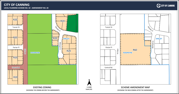
- Rezone Lot 103 (No. 50) Fifth Avenue, Rossmoyne from ‘Private Community Purpose’ to ‘Residential (R60)’; and
- Upcode Lot 9000 (No. 5) Michael Court, Shelley from ‘Residential (R20)’ to ‘Residential (R60)’.
- 20 trees were considered problematic for long-term retention, and their removal is considered appropriate;
- Three verge trees require further arboricultural input and the City’s consideration before a decision on retention; and
- The remaining 98 trees can be considered for retention, subject to a detailed arboricultural review and a Tree Protection Plan.
- Online: Submit your feedback via the survey / Planning Submission Form on the project page. This is the preferred method.
- Email: By completing the submission form (found on the project page) and emailing it to strategic.planning@canning.wa.gov.au; or
- Mail: Send your comments to City of Canning, Locked Bag 80, WELSHPOOL WA 6986.
What is Scheme Amendment No. 20 to LPS 42 proposing?
Scheme Amendment No. 20 proposes to:
Lot 103, formerly the Pallottine Mission Centre site, covers around 1.8 hectares. Lot 9000 is a smaller adjoining vacant lot (740m²). The change would allow the land to be redeveloped for residential housing. The rezoning does not, by itself, approve any specific development; a separate subdivision and development approval process would follow if the amendment is approved.
Wasn’t this originally proposed as R40? Why has it changed to R60?
Yes. Council initiated the amendment at the R40 density in April 2026. As part of the required process, the amendment was then referred to the Department of Planning, Lands and Heritage (DPLH) for the Minister for Planning’s consent to advertise it for public comment. The Minister consented to proceed with public consultation but directed that the density be advertised at R60 rather than R40. The City is required to advertise the amendment in line with the Minister’s direction.
What is the difference between R40 and R60? How many more dwellings can be built?
R40 requires a minimum site area of 180 m² per dwelling, with an average of 220 m². R60 has an average of 150 m² per dwelling and a minimum of 120 m². R40 is more oriented to single houses, grouped dwellings, and small-scale multiple dwellings and has a maximum building height of two storeys. R60 is more oriented toward townhouses, villas, and low-rise apartment-style development with a maximum building height of three storeys, reflecting that vertical, multi-unit product becomes viable at R60.
The landowners proposed redeveloping the site into 52 lots, which would contain both Single Houses and townhouses.
At a R40 density, the sites could yield approximately 55 lots. At a R60 density, the sites could yield approximately 82 lots (an extra 27 lots).
What will happen to the existing trees on the site?
A preliminary tree assessment identified 121 trees on Lot 103 (66 Australian native species, 38 introduced species and 17 Western Australian endemic species). The assessment found:
The concept plan has been designed to provide public open space in two locations on the site so that key groups of mature trees, including stands of River Gums and WA Peppermints, can be retained. Significant trees that are retained would be registered for statutory protection under the City’s Local Planning Scheme No.42 (LPS42) at the subdivision stage.
What is happening to the former Pallottine Mission Centre buildings?
The former Pallottine Mission Centre is not listed on the State Register of Heritage Places. However, it is included on the City’s Heritage List as a Management Category 3 place as a place of ‘some significance’. This classification means that retention and conservation of the buildings are desirable, and any demolition proposal is assessed on a case-by-case basis following a full heritage assessment.
A heritage assessment has been prepared and referred to the Heritage Council for its independent consideration. As part of that process, the Heritage Council recommended that the City request the landowner provide a Heritage Impact Strategy to assist the City in its decision-making around the former Pallottine Mission Centre buildings. The landowner has now provided this strategy for the City’s consideration. It has been proposed to interpret the site’s history through retained mature trees, open space and a commemorative plaque recognising the former mission. A copy of the Heritage Impact Strategy can be found on the project page.
How will traffic and parking be managed?
A Transport Impact Statement estimates the development would generate around 416 vehicle trips per day across the whole site, mostly light vehicles, which is not expected to exceed the capacity of the surrounding road network. New access points are proposed on both Fifth Avenue and Michael Court. Importantly, the internal road network is deliberately not connected through the site and does not connect to the Michael Court cul-de-sac bulb to keep additional traffic on Michael Court to a minimum. Of the site’s 52 lots, 13 would access via Michael Court, which is expected to generate approximately 104 vehicle trips per day off Michael Court, with most of the site’s traffic (around 232 trips per day) directed to Fifth Avenue. Each dwelling would provide on-site parking, and 14 visitor bays are proposed along the internal road verges.
Is the City engaging with the local Aboriginal community?
Yes. The City has reached out to Yokai to seek comment from the local Aboriginal community on the Scheme Amendment, and any feedback received during the advertising period will be taken into consideration.
How is the amendment being advertised, and how can I have my say?
The amendment is being advertised for public comment during the consultation period shown under ‘Key dates’ below. You can provide feedback using one of the following methods:
Should you wish to speak to a planner from the City, you can arrange a one-on-one meeting via the City’s general planning advice service, available Monday to Friday from 9am to 4pm.
What kinds of comments can the City consider?
When assessing submissions, the City generally considers matters that are valid planning considerations. Guidance on what is and isn’t a valid planning consideration is set out in Part 7 of the City’s Local Planning Policy LP.11 – Public Consultation of Planning Proposals.
If you wish, you can also submit a petition. Information on how to do this is available on the City’s website.
Does changing R60 mean the site will definitely be developed at R60?
Not necessarily. After consultation closes, Council will consider a report on the submissions received. The amendment must then be referred to the State Government, as the Minister for Planning is the final decision-maker on Scheme Amendments.
All submissions received during consultation will be provided to the Department and the Commission for the Minister’s consideration. The City’s understanding is that the landowners are currently still proposing to redevelop at an R40 density, and they could still choose to do so even if the sites are coded R60.
Who makes the final decision?
The Minister for Planning is the final decision-maker on Scheme Amendments. The City’s role is to advertise the amendment, consider community submissions, and provide a recommendation to Council before the amendment is referred to the State Government for determination.
Where can I find more information?
Supporting documents, including the amendment report, concept plan and technical assessments, are available on this project page. If you have questions, you can contact the City’s Strategic Planning team using the details under ‘Who’s listening’.